A Roadtrip along the Pacific Coast Highway, California-
Stories, Itineraries, Photos and Suggestions for Your Trip
Rob Gibbs is a 50-something traveller and professional photographer from Australia who runs the photography website Beaches Images. He’s been shooting what he sees for 40 years, and previously put together our definitive guide on How You Can Be A Better Travel Photographer. As it happens, he also loves roadtrips, thinking them necessary to the very essence of his soul (or something like that). One of his favourite USA roadtrip adventures is along the Pacific Coast Highway in California. Without further ado, his stories and suggestions.
The Pacific Coast Highway (PCH), is the strip of tar along the western edge of California. It is renowned as one of the most beautiful and exciting drives in the world. For this article, I have constructed a road trip which is a composite of my three tours of PCH. You can spend as long, or as short a time as you want in this lovely area…for those who just want a quick experience you could hire a Mustang (or a Hyundai Excel) and just experience an exhilarating day trip. For those who have the time you could spend a week or more visiting the various State Parks and hidden gems along the way. This itinerary takes in the most commonly traversed part of the Highway between San Francisco and Los Angeles with two added day trips from these cities. Your experience of the PCH can be totally weather dependent – on one of my trips there was a heavy mist and drizzle all the way along the coastline in the Big Sur area obscuring the coastal cliffs and sea vistas, which was a real downer.
Day 1: San Francisco to Stinson Beach

The area just north of San Francisco is well worth a day trip whilst you are in this wonderful city. Head from downtown north over the Golden Gate Bridge then explore the Golden Gate National Recreation Area. There are many interesting vistas looking back toward the bridge and San Francisco. The park includes plenty of old fortifications, including Fort Barry where the 1950s Nike missile site designed to intercept the ‘new’ Soviet jet bombers has been left basically in its battle ready state and is now a museum.
Sausalito is a picturesque, but very upmarket suburb nearby where the hills meet San Francisco Bay. It has a large public marina and an interesting houseboat community with over 400 boats. There is plenty of bayside dining available at varying luxury levels. We went for the fish and chips with the seagulls.
After lunch head toward Muir Wood National Monument, named after the great John Muir whose environmental campaigns helped launch the USAs excellent national parks system. In Muir Wood you will see awe inspiring giant stands of Coastal Redwoods. Head down to the hill to the coast where you will find Muir Beach, then travel north along the coast on Highway 1. I last did this stretch of road back in 2006 and I swear it was about to fall into the sea. (I checked with Google Streetview and it hasn’t changed.) The road is single lane each way and takes a heavy camber toward the seaward side. The safety barrier only appears to have been placed on the parts of the roadway with vertical drops into the ocean, not those sections with just ‘near’ vertical drops. However, the views on this ten or so kilometre part of the PCH are spectacular.

Arrive at the lovely little coastal town of Stinson Beach for the late afternoon and explore the galleries, gift shops and restaurants. Stinson Beach reminded me a lot of one of those towns you would see portrayed as a hip 60s Beatnik community in those old black and white movies. There are plenty of cosy places here to have an early dinner before returning back to San Fran, with an even more exciting journey this time as the driver is on the edge of the cliff! If you like getting some night photography in, there are some great shots to be had of the Golden Gate Bridge and San Francisco from the northern side of the bridge.
Day 2: San Francisco to Monterey

If you are up and away early in the morning, head over to the Richmond area where some lovely views of the Golden Gate from the ocean side of the bridge are to be had. Then follow the coast road south until you find Highway 1. There are spectacular views from the road as you travel past Pacifica State Beach and the beautiful Grey Whale Cove State Beach on the way to Half Moon Bay.
Pillar Point Harbour is a break-wall constructed enclosure which occupies the northern part of Half Moon Bay. Crabs and fish can be bought directly from the fishing boats here. Half Moon Bay is also the home of the surf break ‘Mavericks’ which has giant waves when the winter storm swells are coming from the right direction. This break is not for the inexperience or faint hearted though, two Hawaiian big wave surfers have been killed here.
The single lane PCH continues along the coast for another 70km or so, the landscape varying between rocky coves and headlands and coastal farmlands until you reach Santa Cruz. If you had a late start from San Francisco, it might be best to make your way via the freeway system through Mountain View directly to Santa Cruz. Just north of Santa Cruz you will find Natural Bridge State Park where there is an interesting rock formation just off the beach.

From Natural Bridge, follow Cliff Drive into Santa Cruz, which traverses many small coves on one side with expensive real estate on the other. You will find the Santa Cruz Surf Museum in the old lighthouse at Point Santa Cruz on Cliff Drive and is well worth a visit. The famous surf break ‘Steamer Lane’ is located just below the cliff here. The beach at Santa Cruz is adjacent to the main downtown area. This place is like Disneyland by the sea, with a massive pier, fair rides, a boardwalk and chairlift along the beach and a tacky ‘Fun Centre’- great if you have kids and lots of dollars, but I couldn’t get out of there soon enough.
We now head south out of Santa Cruz along Highway 1 which heads inland for a bit and soon travels through agricultural areas where great quality fruit can be bought from roadside stalls along the route to Monterey. Many of the lower growing dark green coloured crops are artichokes. Castroville, just south of Monterey, is the ‘home’ of the artichoke, even having a ‘giant’ artichoke in town.

When entering Monterey, follow the signs to Fishermans Wharf, which is worth a quick visit. It is a bit of a tourist trap, with lots of reconstructed sea shanty restaurants and gift shops to take your money…a big plus here though, because there is so much competition, you can sample the clam chowder before you buy, which is nice, and if you try a few… lunch is done for those of you on a budget! There are often classic car auctions and displays held in the parking lot here, which are well worth seeing. Cannery row is an interesting part of town, where Monterey’s once thriving sardine industry was based. It is now a lively area with restaurants, museums, gift shops and the wonderful Monterey Bay Aquarium. Allow at least 2 hours to visit the aquarium. I was blown away by their harbour pier display tank and the spectacular jellyfish display. Monterey is an interesting and historic town, once being the capital of Northern Mexico, until it was taken in the Battle of Monterey during the American-Mexican war of 1846. It was also the capital of California at one stage. Cheap accommodation can be found on the eastern side of town where most of the reasonably priced chains are located.

Day 3: Monterey to Big Sur
This morning starts with a trip into Monterey’s historic downtown area which is designated as a State Historic Park. Some of California’s oldest buildings can be seen along the self-guided walk which can be completed as a downloadable ‘cellphone’ tour.
We then head south out of town and find the signs for “17 Mile Drive”. ‘The Drive’ is a private road through a gated community of coastal mansions, private beaches and exclusive golf courses, NO…country clubs, between Monterey and Carmel. If you are not a resident, you must pay a $10 toll to use the road. Stop off at Bird Rock and Seal Rock to see the amazing variety of bird and sea life. I located and watched a sea otter eating clams for quite some time while a busload of gormless tourists were being entertained by the ubiquitous squirrels beside their bus at the Bird Rock parking area. A small set of binoculars is a must here. The famous Cypress Point and Pebble Beach golf courses are also along this stretch.

Next stop is the Lone Pine at Cypress Point. This part of the coastline is famous for the beautifully gnarled and stunted Monterey Cypress pines, and this one in particular, is iconic. It stands proud on a small pyramid shaped peninsular jutting from the coast. Believe it or not, this particular pine is copyrighted by the Cypress Point Country Club….you can photograph it, but you can’t use these images for commercial purposes! (Thank goodness this is a unprofitable web site.)
We exit the toll road at beautiful Carmel-by-the-Sea. This lovely town has kept its relaxed Californian beachside style, and it does have a stunning strip of sand. There are plenty of stylish cafes and gift shops in the picturesque downtown area to relieve you of your spending money. A warning for those travellers wearing high heels…Carmel has a strange law prohibiting such footwear in their city area, but you can get a free ‘permit to wear’ from city hall. The reason for this? To absolve the city from any lawsuits due to the historically dodgy condition of some of their sidewalks.
Carmel Mission survives from 1771 and is still a place of worship. The museum has some interesting displays for small fee and grounds and buildings are spectacular.


Travelling south from Carmel on Highway 1 we soon come to the Point Lobos State Park. A small entry fee is required here, but there are many short walks and charming coves to explore. I spent a good three hours investigating this park and consider it a highlight of the PCH. It abounds in secret kelp filled coves and carpets of wildflowers in the spring. The whaling museum was very interesting and ranger guided tours are available. I befriended one of the park’s volunteer rangers who had just purchased a digital SLR camera. She got some free photo tips, whilst I got a personal guided tour of this lovely piece of the coastline.
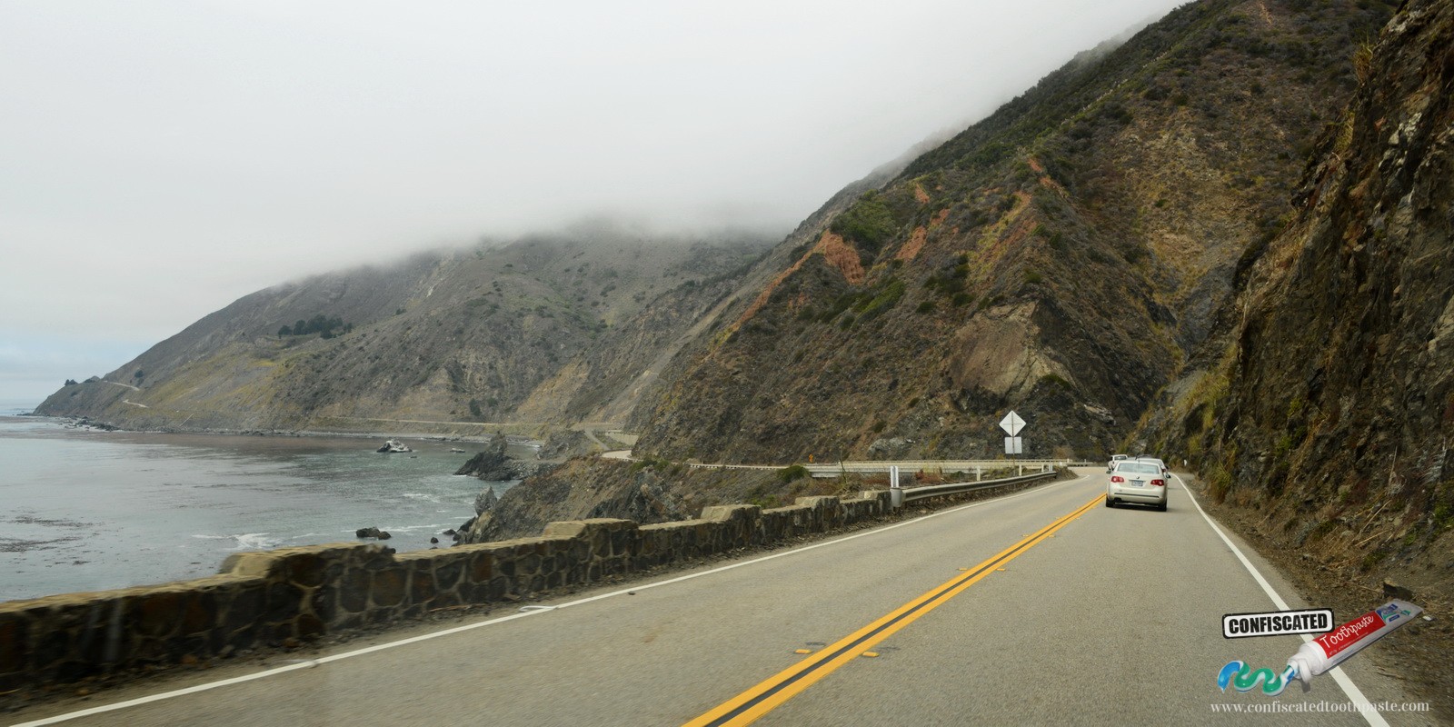
We hit the PCH again, and the drive now moves into gear from the stunning to the extraordinary. The coastal hills become mountains and the road hangs precariously above wave swept rocks hundreds of feet below as the Santa Lucia Mountains rise directly out of the sea in the area know as Big Sur. Most this road has no safety barrier…something that is very unusual in my ‘nanny state’ of Australia. There is also no shoulder, so pay attention whilst driving, because if you run off the road you may not be found for months. If stopping at any lay-bys to look at the view…keep a tight hold of your children. This is seriously hazardous location!


The Big Sur section of the PCH must have been an engineering marvel when it was built, although many parts are in need of repair. Just previous to my last visit to the area, a 50 metre section of roadway had fallen into the sea and was at the time being replaced by a tunnel. The original highway wasn’t opened until 1937 and took 18 years to build using mainly prisoner labour. I stopped for lunch at Rocky Point Restaurant which had panoramic views up and down the coastline and of the stylish Bixby Bridge over which I was soon to traverse. Stop off at Point Sur State Historic Park and try to spot some sea otters, tours are available of the historic light house here, but these only run on certain days of the week. The tours were not operating the day I was here, but come highly rated.

The PCH now heads inland into the mountains where you can camp beside the scenic Big Sur River in a cabin/tent for about $100 a night. It is expensive, but accommodation in this area is scarce and they are pretty flash tents!
Day 4: Big Sur to Cambria
In the morning turn west off Hwy 1 and follow the winding and very narrow Sycamore Canyon Road down to Pfeiffer Beach. It is an adventure just finding this ruggedly beautiful beach which is located where Sycamore Creek meets the ocean. A $5 fee applies to park here. There are some spectacular islands with natural tunnels through them only a few metres off the shore. I was kept amused here for an hour or so by seagulls bathing in a freshwater pool just back from the shoreline.


Make your way back to the PCH and head south where you meet the steep coastline again and soon enough you will see the Jane Pfeiffer State Park. The parking fee/park entry in the carpark here is $10, but can be avoided if you can find a spot on the side of the PCH. There are many trails here, but if you are tight for time, walk along the cliff trail to the McWay Falls overview. This is probably the finest view along the PCH, a scenic waterfall falling directly onto the pretty beach which is located in an equally picturesque cove. If you have time, there is an interesting blowhole at the southern end of the beach, and creek/canyon walks east of the parking area including Canyon Falls.
Next stop along the PCH is Salmon Creek Falls about 30km up the road. There is a parking here with a short walk to the falls proper. Just before the town of San Simeon you will see the Piedras Blancas elephant seal rookery. If you are here at the right time of the year, this is a happening place. The pier at Hearst Beach in San Simeon is nice too. The mountains recede from the coast a little by the time you reach San Simeon, and on my last visit I was greeted by golden paddocks bordered by large eucalypts, herds of cows and barbed wire fencing…it looked surreally Australian!
We arrive at nearby Cambria, which is a reasonably sized town with plenty of budget accommodation.


Day 5: Cambria to Morro Bay
This morning perhaps re-visit the elephant seal colony then get the shuttle bus up to Hearst Castle. Now a State Park, the castle was once the home of William Randolph Hearst, the newspaper magnate. The property is in the Spanish Baroque style and was started in 1919. The castle was still being completed in 1947 when Hearst became too ill to live there. In 1957 the Hearst Corporation gifted the building to the government as they could not afford the upkeep. The castle features 56 bedrooms, 61 bathrooms and full sized outdoor Roman baths. This was the place to be seen in the 20s and 30s. It is a truly magnificent property with wonderful views out over the blue Pacific.


We now do what Mr Hearst did in the Lloyd Cole and the Commotions song, and “fade away to Morro Bay”. On the way to Morro Bay, make sure you take the exit off the highway and visit Cayucos Beach. Cayucos is a typical Californian surf town. It has a great point break and a pier, reminding me a lot of the fictitious town in the great movie ‘Big Wednesday’. You can hire a board here if you are yearning for a surf. Cayucos also has its own boutique brewery…the beer is nice, but the tee shirts are fabulous.
Morro Bay was originally a small fishing village located on an idyllic harbour with the massive Morro Rock guarding the entrance. The locals call it the Gibraltar of the Pacific. Idyllic it was, until the monstrous power station was built guarding the other side of the harbour in the 50s- what were the town planners on? The power station closed down in February this year and is to be demolished…sad for those who have lost their jobs, but great news for the town. Morrow Bay today is very arty, with a cool mix of fishermen, retired hippy types, artists, musicians, surfers and well to do boat owners. The main streets in town are lined with West Australian flowering gums. These trees are a fair age and in summer have a profusion of red blossoms which looks great and frames your views of Morro Rock. There are plenty of lovely seafood restaurants down at the harbour and some nice bars in town. Local music appears really well supported here, one night I watched a country and western band in one bar followed by a punk band in another.


Day 6: Morro Bay to Los Angeles or return to San Francisco
On my last visit from San Francisco, after my overnight stay in Morro Bay, I turned around and drove back to San Francisco in one day. It is like driving a different but equally spectacular road! The view is totally different, because on the way there you were so focused on the road and view in front of you, and likewise on the way back. You can also head over to the interstate and take the fast (but boring) road back to SF or LA.
If you have time, the preferable option is to continue south through San Louis Obispo then along the coast road visiting Santa Barbara, Ventura, Malibu and Santa Monica on the way into LA. Santa Barbara is a very nicely maintained Spanish type town. In Malibu you will find some nice beaches (if you can get to them) and some very impressive real estate. Santa Monica pier is a must do, as is the shopping and restaurants on the Third Street Promenade.


Bonus Day: Los Angeles to San Diego
A suggested day trip from Los Angeles would be to start from Huntington Beach and head south along the coast taking in interesting seaside towns such as Laguna, Oceanside and Carlsbad on the way to beautiful San Diego. Don’t just drive down the freeway, but also be careful to avoid driving into many of the large Marine bases along this stretch like I did once! (What other country has a four lane freeway type road entering their military bases?)
Oceanside has an interesting pier with the generic Ruby’s Diner at the end. La Jolla, a northern suburb of San Diego has some scenic coves and great surf breaks. San Diego is a very neat and tidy city with plenty to see if you have more time. The San Diego Zoo is wonderful and not to be missed – especially the pandas. Sea World also has some fantastic exhibits and educational displays, but they are having issues at the moment regarding the backlash from the ‘BlackFish’ documentary, so you may or may not want to give it a miss based on your ideological viewpoint.


All in all, the PCH packs plenty of punch for your travelling dollar and can be done on most budgets. You will need a car though… although this isn’t too unusual for the USA– ‘Land of the Auto’.
We hoped you liked our guide to California’s Pacific Coast Highway. If you’ve done this route before and have any tips we missed, or you have any questions, feel free to leave a comment below.