An Adventure in the Korean De-Militarised Zone (DMZ)
It is not often I wake up early enough to see the sunrise, let alone have soldiers giving me orders. Or visit a place where I might get shot if I don’t follow those orders. I suppose I lead a less disciplined life than some. But on this hazy Saturday, things were to be different. I was going to visit one of the last vestiges of the Cold War- the Korean Demilitarised Zone (DMZ). The scene of more than 700 acts of violence since the end of the Korean War, the DMZ and Joint Security Area (JSA) at Panmunjeom is also one of the world’s most macabre tourist attractions. I thought I’d better see what all the trouble was about and report back.

I wake at some ungodly hour to grab a quick hotel breakfast before heading off to be at Camp Kim USO base by 7:30 in the AM. Horrifying- and that’s just the dark circles under my eyes when I look in the mirror. I am dressed in my least “offensive”, least “faddish” outfit I could muster, as requested by the UN Command and US military. At the USO base, we are organised into a group and herded onto a bus for the trip to the DMZ. We head northwest out of Seoul, up the Han river. The scenery changes from cityscape to lush green countryside, river and rice paddy. And then as far as the eye can see is barbed wire, encrusting the edge of the river bank, with guard towers appearing periodically. The rice paddies do not stop, but now they are overshadowed by fenced off no-man-lands topped with rolls of razor wire. And then finally we are stopped at the roadblock of Unification Bridge, which leads into the DMZ.
Who or What is a DMZ?
If you don’t know what the DMZ is, don’t fear, because I’m going to explain it to you now. The year was 1945 and the Korean peninsula had just been liberated from Japanese rule. The USA and the Soviets agreed to jointly administer the country, with the Soviet zone north of the 38th parallel and that of the USA to the south. A few years passed and hostilities rose between the West and the East, and the US allies ended up supporting a different Korean leader in the South to whom the USSR and Chinese supported in the North. In the South they were keen on Western style democracy and elections while in the North they thought Communism was a bloody awesome idea. In 1948, Korea was officially split into the Democratic People’s Republic of Korea (DPRK) in the North, and the Republic of Korea (ROK) in the South. But both “countries” claimed sovereignty over the entire peninsula. Then in 1950, the North launched an attack on the South, beginning the Korean War. The South were taken so by surprise that they lost all their territory except for a small area surrounding Pusan, in the extreme south. At this point, the USA entered the war, and the North Koreans were pushed all the way back to the Yalu River in the far north. Then the Chinese entered the war, and pushed the frontline back south again, until it finally stabilised somewhere kind of around the 38th parallel again. Phew. At this point the UN armistice agreement was signed and a ceasefire enforced. Where the soldiers stood at the time of ceasefire became the Military Demarcation Line (MDL). It twists and turns haphazardly with little rhyme or reason. To avoid accidental engagements and misunderstandings, troops were required to retreat 2km back on either side, and to take their heavy weaponry with them. The 4 kilometre strip of land in the middle became the DMZ.

More than 60 years later, we roll across Unification Bridge on our bus, swinging back and forth as we negotiate a set of movable black and yellow barricades designed to slow hostile traffic. The Unification Bridge is a 4 lane bridge over the Imjin River which replaced the older one lane Freedom Bridge. The Freedom Bridge had allowed prisoners of war to return to the South from the border at the end of the war. The newer Unification Bridge was financed by the head of Hyundai, who was a refugee from the North, and it was given its more conciliatory name. After a short drive we arrive at Camp Bonifas, a UN command post just short of the southern border of the DMZ. There we are met by American marines who escort us for the rest of the day.
We are given waivers to sign which indemnify the United Nations Command in the event of bodily injury or death as a result of “enemy action”. Our signatures messy from nervousness, we sign our lives away- quite literally. We proceed under guard past the southern border of the DMZ. It’s fortified to the eyeballs and we pass between rows of massive black anti-tank explosive barricades, masses of minefields and enough barbed wire to sink a ship. Photography is strictly forbidden here.
The DMZ is a Four-Kilometre Wide Ecological Paradise
Bizarrely, we pass into a lushly forested natural oasis. More than half a century with barely any humans has rendered the DMZ a natural wonderland, with hundreds of species of plants and animals flourishing within the 4 km wide strip, including extremely rare birds and big cats including the Korean tiger. Their peace is only disturbed by the occasional hostile incident or by the explosion of one of thousands of land mines. According to our marine, the explosions are occasionally heard back at Camp Bonifas.

As it turns out, there are two villages actually within the DMZ. Daeseong-dong, near the south side of the MDL, had the misfortune to be within the 4 km buffer strip at the time of ceasefire, and is now protected by the UN Command within the DMZ. The direct descendants can still live in the village, and are exempt from military duties and taxation, though they have an 11 pm curfew and must maintain 240 days a year at the village or forfeit residency. About a mile away, on the North side of the border, is Kijong-dong. It is contended by the South that this village is merely for propaganda purposes, and that the town is like a giant Hollywood set designed to give the impression of a high standard of living. Our military escort claims that if you look through telescopes, the windows have no glass, the buildings are but concrete shells and the whole village is tended by staff who turn lights on and off and mow lawns in order to give the impression of permanent habitation. Kijong-dong at one point had the world’s tallest flagpole (at 160 metres, it is now the third highest), built in response to the South’s building of a slightly smaller one (100 metres) in Daeseong-dong.


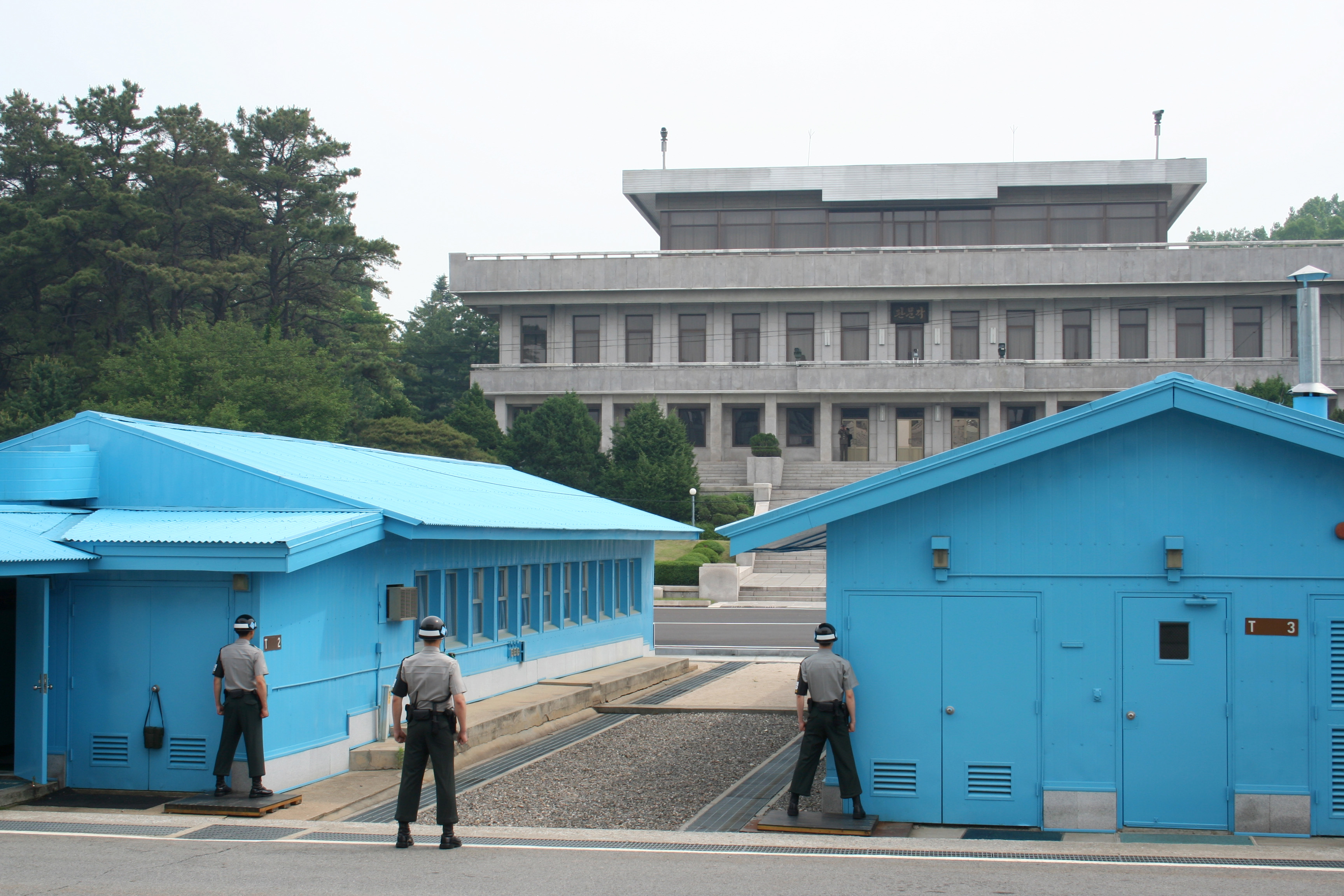
The Joint Security Area (JSA)
Now when most people think of the DMZ, they imagine the Joint Security Area (JSA) at Panmunjeom, which is a rectangular area straddling the border and used to conduct joint negotiations since 1953. Conference Row, a row of small houses used for the negotiations, is built right on top of the MDL border between North and South, which is marked here with a low concrete line between huts, and elsewhere with simple white wooden posts. After all the barbed wire, the lack of any sort of physical barrier at the MDL is something of a surprise. Two imposing buildings, the South’s Freedom House and the North’s Panmun House, stand facing each other across the border. As we file up through Freedom House and to the borderline in single file between US marines and South ROK soldiers, we are watched through binoculars from DPRK soldiers from Panmun House. Statuesque South Korean soldiers stand guard along the MDL. In our enthusiasm to get photos of each other with Conference row and the border in the background, my work colleague Catherine and I get too close to the edge of the area considered safe and one of the “statues” raises his arm suddenly to halt our progress, startling us.
We duly get back in line and file one by one into the main UN conference room straddling the border. This room was also previously subject to “flag wars”, with each side bringing progressively larger flags to sit on the table during meetings until they had to hold a summit on allowable flag sizes. One side of the conference table is on the South side of the MDL, while the other side is on the North. I am quite surprised to be allowed to wander both sides of the room, but frozen South Korean soldiers guard the Northern exit to the room, through which if we passed I am quite sure would be our final deed. It is a real buzz to stand on the North side of the border and look out the window back towards the soldiers guarding the south side of the border.
The Bridge of No Return
The next stop on the tour is Observation Post 5 (now renamed Checkpoint 3), on a hilltop vantage point on the South side of the JSA. This hill is surrounded on three sides by the communist North. From this vantage point, there is an amazing view of the surrounding North DMZ. There is a North Observation post just over yonder in the forest, and we can also see the Bridge of No Return, which crosses the MDL, and which was used to exchange prisoners at the end of the Korean War. The prisoners were brought to either end of the bridge and given the choice to return to whichever side they preferred. If they crossed the bridge in either direction, they could never again return. Around 20,000 prisoners from the North chose not to return to their homeland, while interestingly, around 20 prisoners from the US and Britain held prisoner in the North did not want to leave.

1976 Axe Murder Incident
Right beside the bridge is the old UN Command Checkpoint 3. In days past, the North and South were able to mix on both sides of the border within the JSA. The North built three guard houses in close proximity to Checkpoint 3, which was only visible from Observation Post 5 through the leaves of a poplar tree. This tree was the focal point of the 1976 Axe Murder incident, one of the gravest escalations in tensions since the end of the war. Due to the limited visibility provided by the tree, it was regularly pruned by the UN Command. On one such occasion the DPRK soldiers objected to the pruning being undertaken and when the US and ROK guards refused to suspend the work they were attacked by North Korean reinforcements who arrived across the Bridge of No Return. The tree trimmers in panic dropped their axes, which were subsequently used by DPRK soldiers to kill two US personnel, Captain Arthur Bonifas and 1st Lieutenant Mark Barrett.
Following this incident, the tree was symbolically felled completely three days later by the UN Command under the shadow of heavy military reinforcements. The DPRK guard posts were vandalised and finally removed from this area of the JSA, and the soldiers now stand on either side of the Military Demarcation Line and do not dare to cross it. One exception to this was in 1984, when a Soviet tourist visiting the JSA from the North side suddenly broke away from the group and ran across the demarcation line, yelling that he wanted to defect. He was chased and shot at by pistol wielding DPRK soldiers, who ran right past Freedom House and were engaged in a 40 minute firefight by their Southern counterparts in the garden on the South side of Freedom House. Three of the North Koreans and one South Korean were killed before a ceasefire could be negotiated. Interestingly, Lieutenant Pak Chul, who had commanded the troops accused of the 1976 Axe Murder, was reportedly one of those DPRK soldiers killed during this incursion. The defector was unharmed and began a new life in the West.

On board the bus, we cruise down from Checkpoint 3 past the site of the poplar tree and to the Bridge of No Return, and the bus pauses for photographs, but we are not allowed off the bus. The area is now heavily overgrown and seems deserted. “We just don’t know where the North Koreans might be,” our escort explains. We cruise along the edge of the MDL on our way out of the JSA past rice paddies tended by villagers from Daeseong-dong. “Occasionally, the DPRK will appear and kidnap a villager and drag them across the border, never to be seen again,” he says, followed by a swift admonishment of me for taking a photo.
Exit Through the Theatre of War Giftshop, Please
We arrive back at Camp Bonifas, named after the victim of the axe murder. Among other curiosities, Camp Bonifas has a one-hole “golf course” surrounded by minefields and a bizarre giftshop where you can buy everything from DMZ t-shirts to North Korean banknotes and bottles of North Korean wine and brandy. The liquor looks slightly worrisome with labels that look like they came from a home-made printing press. “It tastes like shit,” we’re informed by our marine. Not a particularly good sales job and I resist the temptation to take home a bottle, though I do buy a banknote (I’m not sure why) and a fridge magnet to add to our collection back home.

Our army escorts leave us and we jump back into the bus with our Korean guide. The first stop is Dora Observatory, which from its vantage point perched high up on Mt Dora, has a wonderful view out over the DMZ. A ROK soldier standing guard suddenly breaks into perfect American English (he was educated at UCLA, it turns out) to give us an explanation of what we are seeing. Though it is hazy, we can clearly make out Kijong-dong, the North’s propaganda village within the DMZ, with its gigantic flagpole, and behind that the city of Kaesong, which until recently hosted workers in industrial facilities from both the North and South.

The Last Train to Pyongyang
Next, we roll into Dorasan Railway Station. This station is northernmost on an historic line that connects Seoul and Pyongyang, and through which trains bound for Kaesong in the North began rolling in 2007 after a thaw in relations between the two sides. Unfortunately the goodwill did not last and Dorasan is now end of the line again. Though looking fresh, refurbished and modern, the station is now again deserted and the unused tracks are surprisingly full of people clambering across them, occasionally yelled at by ROK soldiers standing on the platforms with assault rifles. We take the obligatory photos whilst lying on the tracks and continue on to lunch at a nearby cafeteria. (“Is it really only midday?” I ask, amazed at all the things we have done already.) Though culinary luxury cannot be expected in this remote area the bibimbap and spicy kimchi is passable and we wash it down with mouthfuls of filtered water drunk from the usual UV-sterilised steel cups.


The Third Tunnel into the Bowels of the Earth
In the area is the Third Infiltration Tunnel, our final stop for the day, and for me, one of the spookiest. Four tunnels in total were discovered during the 1970s by the South; there may have been more. The third tunnel was only discovered on information provided by a defector, but at the time of his defection, the North were tunnelling 73 metres underground and were well past the MDL with the tunnel sloping gradually upwards to allow water to flow away from the excavation site back toward the North. In order to try and pinpoint the location of the tunnel, the South sunk evenly spaced PVC pipes filled with water deep into the ground, and one day a dynamite blast within the tunnel caused water from one of the pipes to shoot into the air. A steeply graded interception tunnel was then dug from the South down to meet the infiltration tunnel, with the MDL being blocked off by three concrete walls. Through a window in the final wall, you can see the second wall. Between the first and second is a trap that would send a flood of water downhill toward the North should it be penetrated.
Upon discovery, the North claimed the tunnel was a coal mine, and the coal dust with which they painted the granite walls to try and support their story is still visible. As I am asthmatic with some breathlessness caused by the hazy air, I’m warned (along with those with claustrophobia) to avoid going down into the tunnel. But I grab a hard hat anyway and start the descent down the interception tunnel into the bowels of the earth. The intercept tunnel is dark and steep and moist and eerie. But it’s nothing compared to the actual infiltration tunnel itself that we reach after half a kilometre of walking steeply downhill. The tunnel is dark and extremely confined. Water drips from the ceiling and though there is an air circulation system now installed, it is very hard to breathe. There’s not enough space for a tall guy like me to stand upright, and I wonder if the lack of air is making me stupider as I bash my helmeted head over and over again against the supports on the roof of the tunnel. Though barely wide enough to walk in single file, the tunnel seems to go on forever towards the MDL and it is full of people squeezing past in both directions. It is honestly a claustrophobic’s worst nightmare and with the lack of air I struggle to make it to the concrete walls sealing the end of the tunnel. I don’t stick around for long, and swiftly make my way back the way I’ve come, several times smacking my head against pylons. Though the hard hat takes the brunt of the impacts, several of them are hard enough to cause ringing in my ears. I finally reach the interception tunnel and my breathing getting ever easier, I walk headlong uphill, finally feeling strong enough to jog the last hundred metres, passing dozens of huffing and puffing older tourists from all over the world.

By this stage, we are well exhausted, with our brains bursting with the oddities of the day’s observations. The bus weaves its way back through the barriers on Unification Bridge, and over the next 45 minutes the masses of barbed wire on the sides of the road gradually thin out until we are back again in the bright lights of Seoul in the Western World. But we won’t forget the last remaining interface between the First and Second Worlds, ever-present just 50 km to the north of one of the West’s most successful and modern cities.
*If You Go
Make sure you get one of the official USO tours and pay extra to go to the JSA. It is totally worth it. We went with Koridoor Tours.
If you enjoyed this rollicking good yarn, why not Subscribe? You’ll be informed of everything that is posted on Confiscated Toothpaste and best of all, it’s FREE. Or, like my page on Facebook. We have a merry old time there. As always, I’d love to hear from you in the comments below.